
We begin with Ottoman occupation of the Balkans in the mid-Nineteenth century; the expanding Ottoman empire ruled from Constantinople (later Istanbul). This map shows the distribution of the diverse groups of people living in “European Turkey” and some of its “autonomous vassal states” at the time. The map classifies its ethnography into four groups: is the “Indo-Germanic strain” of Slavs which include Serbs (teal), Bulgarians (light green), Russians (darker green), Poles (black), the Germans (brown), and the Greco-Latins which include Greeks (blue), Romanians (light blue), Vlachs or Aromanians (navy), and Albanians (yellow). is the Agro-Tartar strain of Turks (Deep red), nomadic Yoruk Turks (deep red with lines), Tartars (purple), and Hungarians/Szeklies (Orange with lines). is the Semitic strain of Jews (orange) and Arabs (white with blue polka dots). is “various races”, including the Armenians in cities (slate gray) and “gypsies” or Roma (dark orange). Notice that the Albanians (yellow) and the Serbs (teal) occupy what became Albania and Yugoslavia, respectively. Pockets of Turks (in red) are spread throughout a sea of Bulgarians and Greeks. The Vlachs or Aromanians are found primarily among Albanians, Hungarians among the Romanians, and the tartars to the north. Consider that Macedonia and Macedonians are not mentioned; the French word for mixed salad (macedoine) is supposed to have been inspired by the mix which was the Balkans and eventually gave rise to Macedonia in the middle.

This map of the Austro-Hungarian empire in 1910 is not as detailed as the latter of "European Turkey", but it likewise shows the distribution of a diverse set of populations living in an overlapping empire—this one ruled from Vienna and Budapest. The Slavic group of “Serbs” has been diversified to include Slovenes (gray) as well as Serbs/Croats (khaki) in what eventually becomes the Yugoslav state. Slovaks (brown), Czechs (blue), and Poles (purple) are located in the north alongside germans (pink), although pockets of the latter are distributed among Slovenes, Hungarians (green), and Romanians (orange) especially. Remnants of the Venetian empire of the 16th-18th centuries remain on the “Dalmatian coast” where several Italian communities are depicted in neon green.

In this ethnographic map of the Balkan peninsula, we being to see the distribution of ethnic groups depicted in more granularity. (This is also an early map to organize ethnicity by religious affiliation). After Archduke Franz Ferdinand’s assassination and the start of WWI thereafter, the western Balkans were particularly effected by political reorganization along these religious lines which were generally proxy for empirical allegiances. The Yugoslavs (south Slavs) are, except for the Slovenes, classified by religious affiliation—we see the emergence of the identifier Serbo-Croat, for example, as they are identified as Orthodox, Catholic, or “Islamised”. The Romanians and Greeks are similarly delineated as a form of Christian or “Islamised”. It is interesting to note that Albanians are not given their own ethnic category, but are considered a Macedonian Slav which has been “Albanianised”. This is/was a controversial view.
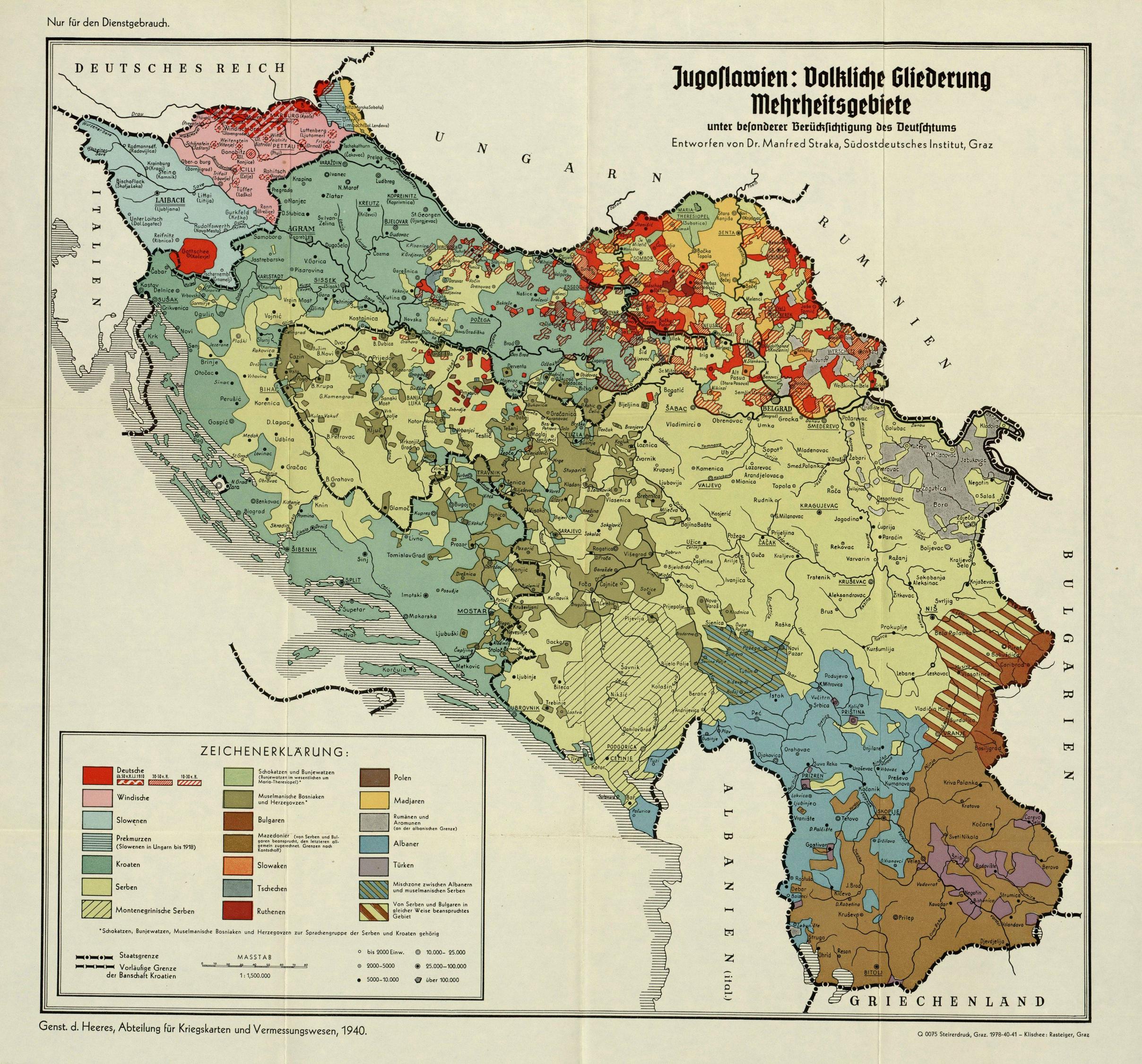
After the collapse of Austria-Hungary, the slavic peoples occupying the western Balkan lands fulfilled their desire to become a sovereign nation state through the Kingdom of Serbs, Croats, and Slovenes—Yugoslavia. The european debate over lands and nations was not finished, however, and the Axis powers invaded Yugoslavia during World War II. The Nazi agenda had long identified Jews, Slavs, and Gypsies as sub-races and a particular threat to racial purity, and these populations were targeted by the Einsatzgruppen (Nazi death squads) as they swept through eastern europe. Germany, like France, Great Britain, and other countries with established academic traditions, had been a center of mapmaking prior to this period. Still, it is interesting to view a map of “national division majorities with special consideration of Germanism” in this context. Accordingly, this map is interesting for its identification of the long-standing buffer zone between Slavic and Germanic peoples in Europe — the Germania Slavica. The map identifies the Windisch (pink), a German term for Slovenian-speaking peoples as well as the Slovenians (light blue). The Prekmurzen, Slovenians in Hungary, are also identified (striped blue). The once vibrant Jewish communities of the Balkans are no longer visible in ethnographic distributions.

During the Cold War, Yugoslavia assumed a position of nonalignment...This map shows the distribution in the 48 United States of births to mothers under the age of 20 years old in 1982. Shadings are used to show the five categories of data. The states with the higher number of births to mothers under 20 are in the southern part of the United States.

A decade later, and war broke has broken out between various factions within Yugoslavia. Tito’s leadership has also come to an end, and reports of ethnic cleansing draw the world’s attention to the Balkans. Widespread population shifts are observed in this period; again, notice the speckled pockets of Bosnia—once touted as a Yugoslav heaven of ethnic coexistence. The autonomous province of Vojvodina is also quite diverse (known especially for the Hungarian minority).

The ethnic coexistence model fails in Bosnia, where external peace efforts (not wholly successful) sought to broker a canton system. Bosnia becomes a confederation, but not before thousands of refugees flee the former republic. Reasonably intermixed areas become significantly more segregated. Areas in red (srbi for Serbians) are roughly the new border of the Republika Srpska (Serbian republic), areas in blue are roughly the croat-majority cantons (including the region of Herzegovina on the southwest edge which remains in Bosnia’s name), and areas in green are bosniak (bosnian muslim) majority areas.

While the former Yugoslavia navigates its uneasy peace, growing tensions between the Albanian majority and Serbian/Yugoslav government in Kosovo result in another violent conflict. Kosovo declares independence via an Albanian majority in 2008.

Today, the Serbian government has not yet recognized Kosovo as independent, and Serb-majority areas (especially in the North), struggle to find their place. Bosnia remains a checkerboard of ethnic communities, and the whole region attempts to navigate their role between east and west as various efforts at democratization, european integration, infrastructure development bids, and investment in various forms continue to knock from familiar corners.
Produced by Anlan Cheney.